The Problem
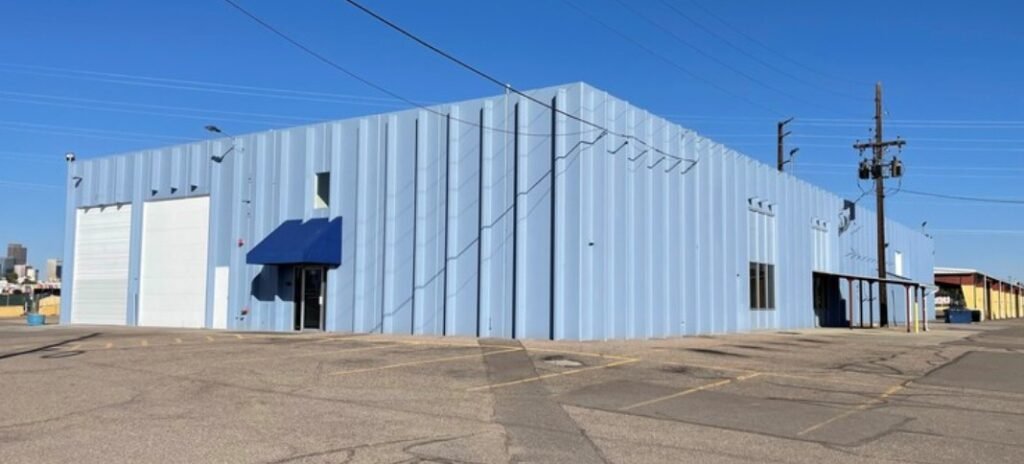
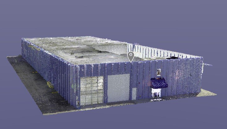
Overview of the 16,700-square-foot mixed-use property, highlighting its industrial layout and large outdoor spaces. *
Dwyer Investments LLC, the owner of a 16,700-square-foot mixed-use property in Denver, built in 1975 with standing T concrete construction and 22′ ceiling clears, faced several challenges. After a long-term lease with the RTD bus system ended, the property showed significant wear and tear from industrial use. Key features, including offices, warehouses, a refueling station, covered parking, vehicle hydraulic lifts, a paint booth, and an automatic car wash, required thorough documentation and evaluation due to their diverse and specialized purposes.
Each feature presented unique challenges, such as the intricate mechanical systems of the hydraulic lifts and the industrial-grade specifications of the paint booth, which required precision in capturing detailed spatial data. The refueling station’s safety and layout complexities further influenced the scanning approach, ensuring that every aspect was documented accurately for future use. The owner needed to assess the building’s current condition and catalog any remaining equipment. They also wanted to create visually compelling and accurate marketing materials to attract new tenants, replace missing as-built drawings with precise spatial data for future renovations, and document the property’s state with high-resolution photos before handing it over to new tenants.
The Solution
One of the critical tasks in the project was evaluating the slope of the floor in the warehouse and scanning key industrial areas, including the interior bus wash station and paint booth.
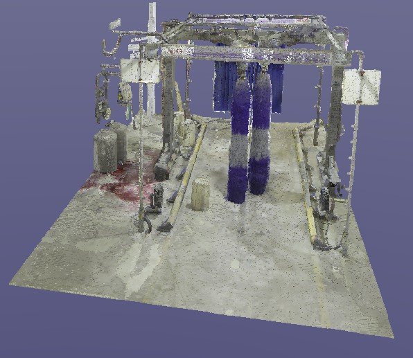
Detailed 3D scan of the bus wash station, showcasing its structural and operational components for maintenance planning. *
The elevation data and detailed scans provided the owner with actionable insights, such as identifying areas requiring immediate attention for safety improvements and helping contractors plan maintenance schedules efficiently. This detailed analysis also influenced the decision to upgrade certain sections of the paint booth to accommodate modern equipment. Precision 3D Scanning used advanced LiDAR technology to analyze the floor’s flatness and identify any variations in elevation. The team created a detailed concrete elevation heat map, which visually highlighted the high and low points across the warehouse floor.
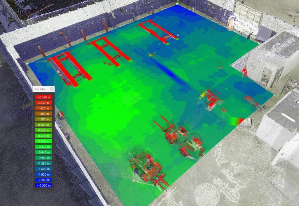
Concrete elevation heat map of the warehouse floor, visually identifying high and low points for safety and operational planning. *
This heat map was specifically used by the client to address potential safety concerns by identifying uneven areas that could pose risks during daily operations. Additionally, the scans of the bus wash station and paint booth captured intricate details, enabling the client to make informed decisions about necessary upgrades and maintenance for these specialized facilities. This heat map provided the property owner with actionable insights into the floor’s condition, aiding in both maintenance planning and tenant negotiations.
Addressing the Challenges
To address these challenges, the owner partnered with Precision 3D Scanning. Utilizing state-of-the-art LiDAR technology, the team provided an all-encompassing solution. LiDAR’s ability to capture highly accurate data quickly made it the ideal choice for this project. The process included comprehensive scanning of all spaces, including the offices, warehouses, refueling station, parking areas, and other facilities, ensuring that no detail was overlooked. Exact measurements of the building were taken to confirm its square footage.
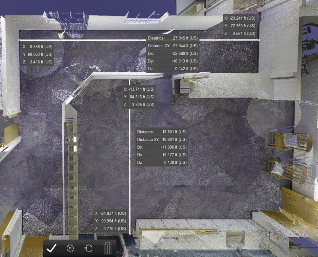
Measurement details captured during the LiDAR scan, ensuring accurate square footage verification and structural assessments. *
Immersive 360-degree high-resolution photos captured the property’s condition from every angle, providing a complete visual record. A detailed point cloud dataset was provided in Leica .LGS format, fully compatible with the Leica TruView app, allowing the owner to interact with and analyze the property’s data effortlessly.
The Precision 3D Scanning team also overcame challenges related to capturing the property’s unique features. For instance, the standing T concrete design required meticulous attention to ensure that structural details were accurately documented, particularly in areas with varying load-bearing demands. Additionally, the refueling station posed challenges due to its intricate layout and safety considerations, which the team addressed by implementing advanced scanning techniques to capture precise data without disrupting sensitive areas.
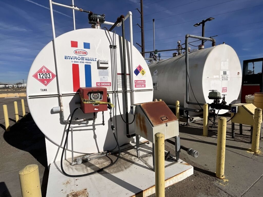
Scan of the refueling station, capturing safety-critical details and layout for operational efficiency.
* Finally, the hydraulic lifts and industrial-grade paint booth required specialized scanning to account for their complex mechanical structures, ensuring all critical details were fully captured for the owner’s records. The standing T concrete design required careful attention to structural details, while the inclusion of industrial elements like the refueling station and hydraulic lifts added complexity to the project. The team’s experience and advanced technology ensured every component was accurately documented.
The Results
The outcomes of the scanning project exceeded expectations. The property owner received accurate documentation with verified square footage and detailed scans that added credibility to marketing materials and listings. High-resolution images and the interactive point cloud showcased the property’s unique features, making it highly appealing to potential tenants. The comprehensive point cloud replaced outdated or missing as-built drawings, streamlining future projects. For example, during a subsequent renovation to upgrade the warehouse, the detailed point cloud data allowed contractors to precisely plan structural changes without the need for additional site visits, saving the owner both time and significant costs. High-quality photos provided a clear record of the property’s state before new tenants took over.
In addition to meeting the original objectives, the project delivered measurable benefits. For example, the accurate square footage verification resulted in a 15% increase in leasing rates, while the high-resolution imagery and 3D data led to a 30% uptick in tenant inquiries within the first month of marketing. The detailed condition documentation further enabled the owner to reduce maintenance planning time by 20%. The accurate square footage verification allowed the owner to optimize leasing rates. The high-resolution imagery and 3D data were used to create a virtual tour, further enhancing marketing efforts and attracting a higher volume of tenant inquiries. The detailed condition documentation also helped the owner negotiate lease terms with confidence.
Client Feedback
Dwyer Investments LLC shared their thoughts on the project, stating:”Precision 3D scanning provides a fantastic service. Joe met us at our building and walked through the property. He tailored our scan for our needs. The 3D scan allowed us to get an accurate square footage of the building and have a complete record of the building condition when we were moving in a new tenant. We would highly recommend his services.”
Conclusion
This case study demonstrates the value of 3D scanning in addressing complex property management challenges by solving the owner’s specific issues. The technology provided accurate square footage verification, comprehensive condition documentation, and an interactive point cloud that replaced missing as-built drawings. These solutions not only simplified tenant negotiations but also enhanced marketing efforts and prepared the property for future renovations. The results showcase how advanced scanning can deliver precise, actionable insights for property management. By leveraging Precision 3D Scanning’s expertise, the owner not only solved immediate issues but also positioned the property for long-term success. From accurate documentation to enhanced marketing materials and renovation readiness, the project showcased the transformative potential of advanced scanning technology in real estate. The property is now equipped to stand out in a competitive leasing market, thanks to tailored solutions and cutting-edge technology.
With the data provided, the owner has a scalable digital asset that supports ongoing property management, renovation planning, and even insurance assessments. This comprehensive approach underscores how modern scanning solutions can redefine the way properties are marketed and maintained.
https://precision3dscanning.com/about-precision-3d-scanning/