Introduction
Urban development is never a blank canvas. Every project unfolds in a landscape already shaped by storm drains, sewer lines, water mains, telecom conduits, and utility corridors. For developers, the excitement of a new property often comes with a shadow of risk: if something breaks, the city may point to the most recent construction.
Flooding in the street, a collapsed sewer, or cracked sidewalks might have been brewing for years, but when these problems surface, the developer is often the first to blame. Without proof of existing conditions, defending against these claims becomes difficult and expensive.
This is where LiDAR scanning steps in. By capturing a complete, timestamped digital record of site conditions before construction begins, developers create both a design resource and a protective shield.
The Risk Landscape
Developers working in cities face overlapping risks. Drainage is a constant source of disputes, especially when heavy rain reveals ponding near a new property. Sewer and utility tie-ins often become another flashpoint when old records fail to match real-world conditions. Even after successful completion, developers may face claims years later for pavement failures, sidewalk settlement, or utility disruptions.
The reality is simple: without evidence of how things looked before construction, a developer may be held responsible for conditions they never caused.
How LiDAR Scanning Works
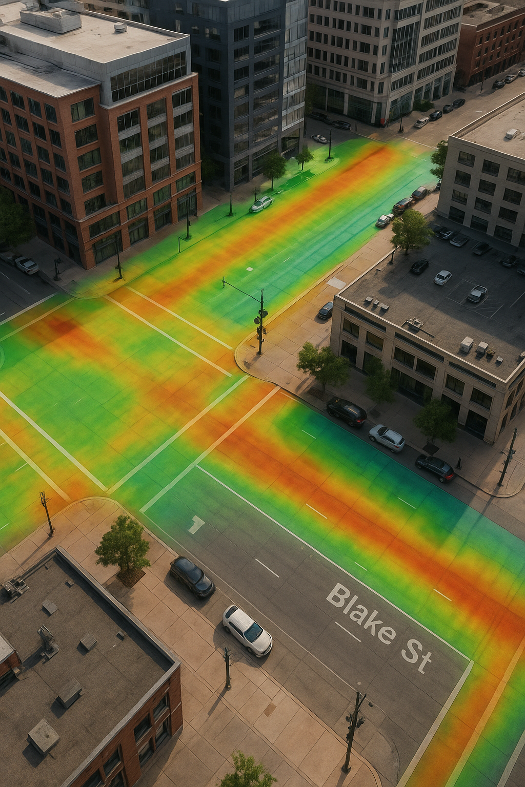
LiDAR technology uses lasers to capture millions of measurements per second, producing a dense point cloud that recreates the site in three dimensions. Unlike traditional surveying, which captures select features, LiDAR captures everything visible in its range from the subtle slope of a gutter to the exact alignment of a manhole cover.
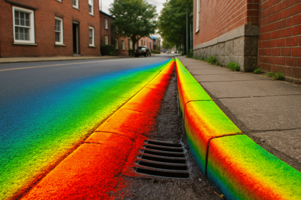
The point cloud becomes a digital twin, offering unmatched accuracy and context. Elevation heat maps derived from the scan highlight slope changes and potential drainage issues. Every curb, inlet, and street corner is recorded, preserving the site as it existed before the first piece of equipment moved in.
Drainage and Sewer Protection
Stormwater is one of the most contentious issues in urban development. Cities want assurance that runoff patterns are unchanged, while neighbors are quick to raise concerns if water pools near property lines. Sewer backups are equally problematic, and a misaligned tie-in can quickly turn into a legal dispute.
LiDAR scanning provides proof. By documenting slopes, grades, and the location of inlets and manholes before construction, developers can demonstrate compliance. After the project, a follow-up scan creates a before-and-after record that settles disputes without argument. When questions arise, data speaks louder than assumptions.
Utility and Infrastructure Confidence
Urban sites are woven with layers of visible and hidden infrastructure. Water, power, gas, and telecom networks converge near property lines, and tie-in points are rarely documented with precision. A single misplaced connection can trigger delays, cost overruns, and disputes.
LiDAR captures what is visible and places it in context. Manholes, vaults, and access covers are locked into the record. Their positions are no longer a matter of interpretation but of measurable evidence. If damage is later discovered, the developer can prove whether it was pre-existing or a result of later work. That confidence changes how a developer negotiates with both inspectors and utility providers.
Shared Accountability
Cities, utilities, and communities all want accountability. LiDAR scanning makes it possible. Instead of relying on outdated as-builts or partial survey notes, stakeholders review the same dataset. This shared visibility reduces conflict, accelerates approvals, and builds trust between developers and regulators.
For a developer, it means disputes don’t have to turn into battles of opinion. Everyone works from the same source of truth.
More Than Protection
Risk management may be the driving factor, but LiDAR brings added benefits. Design teams can integrate the scans directly into their workflow, reducing conflicts and errors. Cities often move approvals faster when presented with accurate documentation. Investors view the use of LiDAR as a sign of responsibility and forward planning. The digital record itself becomes a long-term asset, useful for future renovations, resale, or refinancing.
In many ways, the scan is more than insurance, it’s proof of professional diligence.
Case Example
A developer completing a downtown project faced claims after a heavy rainstorm left an intersection flooded. The city argued that grading changes had redirected runoff.
The developer had invested in a pre-construction LiDAR scan. The data revealed that storm drains near the site were already deteriorating before construction. Elevation data showed that site slopes had not changed. Faced with this evidence, the city dropped the claim.
That one scan saved the developer from costs, delays, and reputational harm. It also reinforced how LiDAR creates lasting value beyond construction.
Best Practices
Developers who want full protection should follow a clear workflow:
- Begin with a pre-construction scan that documents site conditions and surrounding infrastructure.
- Provide the point cloud to design teams for grading and utility planning.
- Re-scan at key milestones, such as after excavation or before paving.
- Complete a final post-construction scan to confirm compliance and restoration.
This layered approach preserves accountability from groundbreaking through completion and years beyond.
Final Thoughts
Urban development is filled with challenges that don’t always come from the building itself but from the world around it. Storm drains collapse, utilities fail, and neighbors raise concerns. Developers without documentation may find themselves carrying responsibility for problems they never caused.
LiDAR scanning changes the equation. It creates a permanent, timestamped record that protects developers, supports design teams, and reassures regulators. When disputes surface years later, the developer with a LiDAR record doesn’t have to argue. They can simply show what existed before construction began.
That clarity protects profit, preserves reputation, and ensures projects succeed without unexpected consequences.
Ready to safeguard your next project with LiDAR scanning? Contact Precision 3D Scanning today to discuss your site and get protected from future risk. https://precision3dscanning.com/lidar-scanner-pricing-request-a-quote-precision-3d-scanning/