Accuracy drives everything in construction. From the first benchmark set by the surveyor to the last inspection before handover, every coordinate matters. Two technologies dominate the conversation around field accuracy today: LiDAR scanners and total stations.
Both measure space, both deliver millimeter-level data but their roles are not the same. Understanding where each tool fits can make the difference between a smooth project and a costly rework.
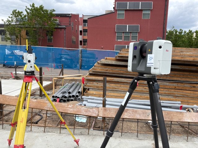
What a Total Station Does
A total station is the construction site’s precision instrument. It measures angles and distances from a single point and reports exact coordinates—X, Y, Z—to define where a line, column, or anchor should go.
For layout and stakeout, nothing replaces it. Whether setting control points, aligning curtain wall embeds, or verifying steel, a total station tells you exactly where to place or confirm a point in physical space.
In Colorado’s construction market, where terrain, weather, and complex sites often challenge precision, total stations remain essential for field layout and verification.
What a LiDAR Scanner Does
A LiDAR scanner, such as the Leica RTC360, captures everything it sees. It emits laser pulses millions of times per second, recording each reflection as a precise coordinate. The result is a point cloud. A dense 3D snapshot of the entire environment.
Unlike a total station that measures a few points, LiDAR collects millions. That density makes it ideal for:
- As-built documentation
- Elevation and deviation analysis
- Clash detection and BIM modeling
- Preconstruction condition verification
When tied to control, a LiDAR scan can align perfectly with design data or survey baselines. This connection allows contractors, architects, and engineers to make decisions backed by verified, measurable truth.
LiDAR and Total Stations: Not Competitors But Complements
In the field, these two tools don’t compete; they collaborate.
A total station gives you a known truth. A small number of verified points in space.
A LiDAR scanner gives you the full picture. A detailed 3D representation of everything between those points.
When combined, you get an as-built environment that is both accurate and complete. The total station anchors your scan to real-world coordinates, and the LiDAR scanner fills in every surface and detail.
Comparison at a Glance
| Function | LiDAR Scanner (e.g., Leica RTC360) | Total Station |
|---|---|---|
| Purpose | Capture existing conditions quickly in 3D | Layout, stakeout, and control |
| Data Type | Millions of points forming a 3D model | Single points (X, Y, Z) |
| Accuracy | 2–4 mm (when registered to control) | 1–2 mm |
| Speed | Millions of points per minute | Slower, one point at a time |
| Use Cases | As-builts, deviation maps, BIM modeling | Layout, control, coordinate verification |
| Output | Point clouds, models, heat maps | Coordinates, control points, layout marks |
| Best For | Verification and analysis | Building and layout |
When to Tie LiDAR to Control
Tying LiDAR data to survey control is what turns “pretty pictures” into measurable truth. It’s not always necessary but when accuracy matters, it’s essential.
When to tie to control:
- You’re comparing scans to design models or previous surveys
- You’re creating deliverables used for layout or fabrication
- You’re documenting pre-existing conditions for renovation or addition work
- Multiple scans will be combined or shared across teams
When it’s not required:
- Quick interior visuals or single-room references
- Concept modeling where relative accuracy (not absolute) is enough
At Precision 3D Scanning, we routinely tie LiDAR data to control when scan data will drive design, coordination, or procurement decisions. It’s an extra step that ensures data integrity when the project depends on it.
Benefits of Using Both
The strongest workflows combine survey precision and LiDAR completeness:
- Faster verification: Instead of checking a few points manually, you can validate the entire surface digitally.
- Reduced rework: When models are based on true conditions, design errors get caught before field installation.
- Improved communication: A dense 3D point cloud visualizes the jobsite for teams who aren’t there in person.
- Traceable accuracy: Control-tied scans provide confidence for dispute resolution and change-order justification.
In short, the total station tells you where, and the scanner shows you everything around it.
How This Impacts Colorado Projects
Colorado’s construction environment is uniquely challenging. Diverse elevations, variable weather, and tight project schedules. LiDAR and total stations together offer a way to minimize uncertainty.
On complex projects across Denver, Boulder, and the Front Range, this dual-technology approach has become the standard for GCs, engineers, and architects who expect verifiable accuracy at every stage.
With growing emphasis on digital coordination and remote review, the ability to produce survey-locked, visually rich LiDAR data is changing how Colorado teams plan, verify, and build.
Common Misconception: “Can a Scanner Replace a Total Station?”
No.
A scanner captures data. It doesn’t guide you to a coordinate in the field.
For layout, stakeout, or establishing new control, you still need a total station.
For verifying and documenting existing conditions, a LiDAR scanner is unmatched.
They serve different purposes. But together, they deliver a feedback loop of build → verify → improve that defines modern construction accuracy.
The Future of Field Verification
As LiDAR becomes faster and more accessible, more teams are using scanners not just for as-builts, but for real-time decision-making. Integrations between Leica’s RTC360, Cyclone REGISTER 360 Plus, and tools like Jetstream and Rithm are closing the gap between scanning and actionable insight.
Total stations will always lead in layout precision and scanners are redefining what “as-built” truly means. The combination ensures that data accuracy is no longer a specialty. It’s the standard.
Final Thoughts
LiDAR scanners and total stations are not rivals. They’re partners. One defines control, the other defines context.
Together, they give project teams the confidence that every decision is based on measurable reality.
You use a scanner to understand reality.
You use a total station to build it.
If your Colorado project depends on accurate field data, connect with Precision 3D Scanning to learn how LiDAR can verify your design, protect your schedule, and elevate your results.