Preserving History
Preserving historical monuments, buildings, and sites is crucial for maintaining cultural heritage and history. As these structures age, the challenge of restoration and preservation becomes more complex. However, advancements in technology, particularly 3D LiDAR scanning, have revolutionized the way we conserve these important sites. LiDAR (Light Detection and Ranging) allows experts to create detailed, accurate models of historical landmarks, enabling more effective preservation, restoration, and documentation. 3D LiDAR Scanning Point Clouds are Preserving History.
LiDAR scanning captures millions of data points to create high-resolution 3D models of existing structures. This precise, non-invasive method not only helps identify structural issues but also ensures that restoration work respects the original architecture. This blog explores how 3D LiDAR scanning is being used in historical preservation, focusing on three key examples: the ancient city of Pompeii, the Cologne Cathedral in Germany, and Mount Rushmore in the United States.
The Role of Point Clouds in Historical Preservation
A critical component of 3D LiDAR scanning is the creation of point clouds, which serve as the foundation for detailed digital models of historical structures. A point cloud is a collection of data points in a three-dimensional coordinate system, representing the surface geometry of objects or spaces. Each point represents a precise location, allowing for the creation of accurate, high-resolution 3D models of complex historical monuments, buildings, and sites.
Point clouds have transformed the way architects, conservators, and preservationists approach restoration and conservation. By providing a detailed digital replica of a structure, point clouds offer several key advantages in historical preservation:
- Detailed Analysis: Point clouds provide highly accurate measurements of structures, including hard-to-reach areas. This allows conservationists to analyze even the most intricate details of historical sites, such as carvings, reliefs, or ornate facades, without physically interacting with the structure.
- Condition Assessment: The data from point clouds can be used to assess the condition of a monument or building. By comparing scans taken at different points in time, preservationists can identify signs of wear and tear, such as cracks, erosion, or shifting elements. This makes it easier to prioritize areas in need of restoration and develop targeted conservation strategies.
- Efficient Restoration Planning: Point clouds enable architects and restoration teams to create precise plans for repair and maintenance. The 3D models derived from point clouds serve as a blueprint, helping experts recreate lost or damaged architectural features with a high degree of accuracy. This is especially important for intricate historical details that require faithful reproduction.
- Documentation and Archiving: Point clouds serve as an invaluable digital record of historical monuments, preserving their current state for future generations. Should a monument suffer damage due to natural disasters, accidents, or environmental factors, the point cloud data can be used to guide the restoration process with pinpoint accuracy. In some cases, these digital replicas may be the only remaining record of a site’s original state, especially if significant changes occur over time.
Preserving the Ancient City of Pompeii
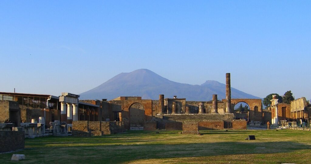
The ancient city of Pompeii, buried by the eruption of Mount Vesuvius in AD 79, has long been a valuable archaeological site. However, the site faces significant preservation challenges due to exposure to the elements and the passage of time. To protect the integrity of this historical wonder, archaeologists have turned to 3D LiDAR scanning.
Using LiDAR, researchers have scanned large sections of Pompeii, capturing every detail of its streets, buildings, and artifacts. The technology allows archaeologists to create a precise 3D map of the entire site, preserving its current condition digitally. This digital preservation ensures that even if sections of Pompeii are lost or damaged over time, the detailed data can be used for future restoration or study.
LiDAR scanning has also been instrumental in uncovering previously hidden areas of the city. It penetrates dense vegetation and rubble, revealing new structures and pathways that were once buried under layers of ash. This data allows historians to better understand Pompeii’s urban planning and cultural life while helping conservators prioritize areas in need of immediate attention.
In Pompeii’s case, 3D LiDAR scanning not only aids in restoration but also acts as a time capsule, preserving its current state for future generations.
Pompeii and Point Cloud Documentation
In Pompeii, point clouds generated from LiDAR scanning are used to document the site in unprecedented detail. These point clouds allow researchers to virtually walk through the ancient streets and buildings, analyzing their construction and layout without disturbing the fragile structures. The ability to visualize the site in 3D from a digital model has revolutionized the way archaeologists and historians study and conserve the site, giving them access to detailed spatial data that informs every aspect of preservation efforts.
Learn more about this project here: https://lidarmag.com/2022/12/23/integrated-sensors-emerge-in-pompeii/
Safeguarding the Cologne Cathedral in Germany
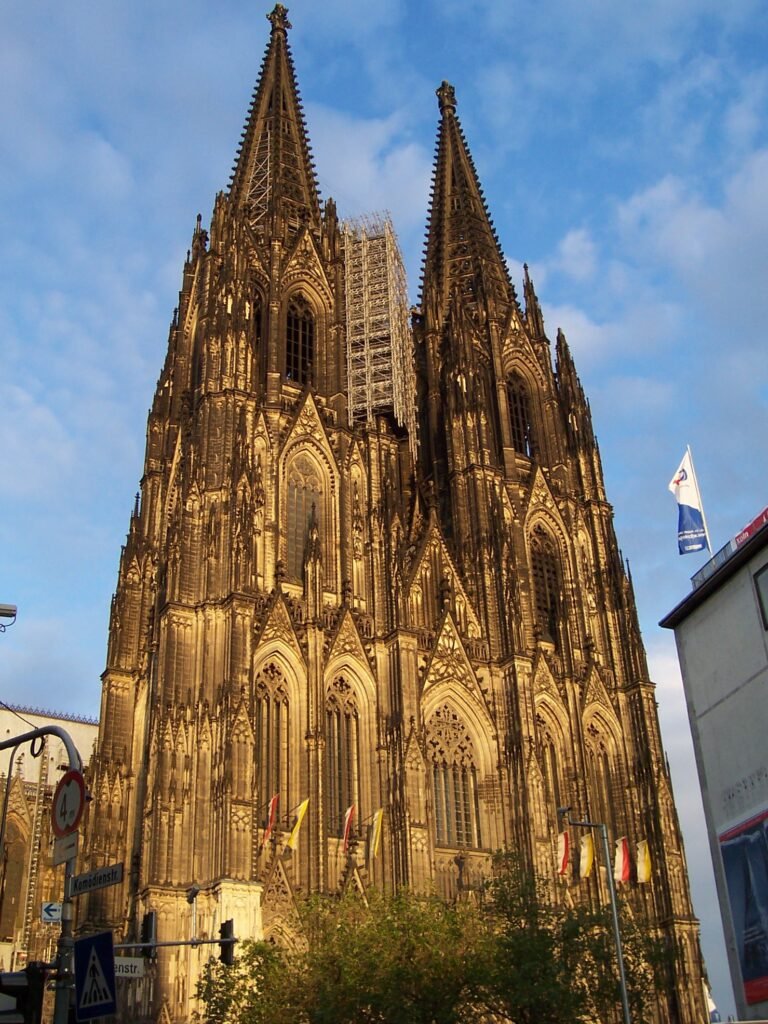
The Cologne Cathedral, a UNESCO World Heritage site and one of Germany’s most iconic landmarks, stands as a masterpiece of Gothic architecture. However, this architectural marvel, completed in 1880 after over 600 years of construction, faces ongoing challenges from weathering, air pollution, and the natural wear of materials.
To ensure the cathedral’s longevity, conservation teams have employed 3D LiDAR scanning technology. 3D LiDAR Scanning Point Clouds are Preserving History. The cathedral was scanned in its entirety, with every stone, spire, and stained-glass window captured in precise detail. This comprehensive 3D model allows experts to monitor the cathedral’s condition over time, identifying areas that may need immediate repairs or conservation efforts.
At the Cologne Cathedral, point clouds provide conservators with a precise digital model of the entire structure. By scanning the cathedral at regular intervals, experts can compare point clouds over time to track any changes in the building’s structure. If a crack develops or a stone deteriorates, the point cloud will highlight the change, enabling conservators to address the issue before it worsens. This process allows for continuous monitoring and preservation of the cathedral’s intricate Gothic details.
LiDAR data also aids in planning restoration projects. For instance, if a particular gargoyle or section of the façade deteriorates, conservators can refer to the 3D scan to recreate the damaged portions accurately, ensuring that the restoration stays true to the original design. By having a detailed model on hand, restoration teams can work more efficiently and with greater precision, reducing the risk of errors that could compromise the building’s historical integrity.
Moreover, the LiDAR scan of the Cologne Cathedral serves as an invaluable tool for future generations. Should any unforeseen damage occur, such as natural disasters or accidents, the data can be used to restore the cathedral to its original state with unparalleled accuracy.
More on how they did it here: https://www.geoweeknews.com/news/3d-scanning-largest-building-world-1800s
Mount Rushmore in the United States
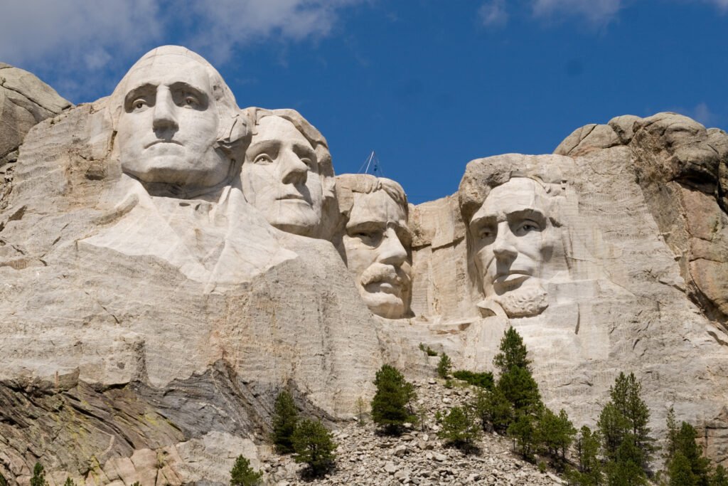
Mount Rushmore, one of the most recognizable monuments in the United States, faces unique challenges in terms of preservation. Carved into the granite face of the Black Hills, the sculptures of four U.S. presidents—George Washington, Thomas Jefferson, Theodore Roosevelt, and Abraham Lincoln—are subject to natural erosion caused by weather, freeze-thaw cycles, and human activity.
In response to these threats, the National Park Service collaborated with various technological experts. They conduct a 3D LiDAR scan of Mount Rushmore. The scan provided an extraordinarily detailed digital record of the monument. It captured not only the likenesses of the presidents but also the intricate textures and details of the surrounding rock. (For more information, click here: https://blog.lidarnews.com/laser-scanning-mt-rushmore/ )
Point clouds have been crucial in monitoring the surface of Mount Rushmore, which is subject to weathering and erosion. Point clouds capture the monument in high resolution, allowing preservationists to identify small cracks or areas where erosion is occurring. This information helps them take preventive measures to slow down the erosion process and ensure the long-term stability. Additionally, the point cloud serves as a reference for potential restoration work of the monument in the future.
This 3D data is essential for monitoring Mount Rushmore’s condition over time. By comparing scans from different periods, conservationists can track the rate of erosion and identify areas that may require intervention. 3D LiDAR Scanning Point Clouds are Preserving History. If a crack begins to form or if small pieces of the granite deteriorate, scans enables conservationists to respond quickly.
Additionally, the detailed 3D model serves as a backup plan for future restoration efforts. Should the monument suffer damage from natural disasters or environmental factors, the scan can be used to guide precise restoration. This ensures that the original design is faithfully preserved. This technology not only protects the monument’s physical integrity but also secures its legacy for future generations.
How 3D LiDAR Scanning Is Changing Historical Preservation
LiDAR scanning offers several advantages in the preservation of historical monuments, buildings, and sites:
- Precision: LiDAR captures even the smallest details with exceptional accuracy, allowing for exact measurements and modeling of structures. This precision is critical when restoring or maintaining intricate architectural features.
- Non-invasive: LiDAR scanning is a non-contact method, which means there’s no risk of damaging fragile or ancient structures. This makes it ideal for preserving delicate historical sites.
- Efficiency: By creating a comprehensive digital record of a site, LiDAR scanning speeds the planning and execution of restoration projects. Teams can work more efficiently, reducing the time and resources needed for preservation efforts.
- Long-term monitoring: Regular LiDAR scans of historical sites allow conservationists to monitor changes over time. They can identify early signs of deterioration, enabling timely interventions to prevent further damage.
- Digital preservation: In addition to aiding physical preservation, LiDAR scans create digital replicas of historical sites. These replicas serve as backups in case of damage and can be used for research, education, and even virtual tourism.
Preserving History with 3D LiDAR and Point Cloud Technology
3D LiDAR scanning is transforming how we preserve and protect historical monuments, buildings, and sites. From Pompeii to the Cologne Cathedral to Mount Rushmore, 3D LiDAR Scanning Point Clouds are Preserving History. This technology offers precise, non-invasive, and efficient solutions for ensuring that these cultural treasures endure for future generations. LiDAR captures fine details, helping conservators plan restorations that respect original craftsmanship. It safeguards against modern threats.
Point clouds are essential in preserving historical sites, allowing experts to analyze and restore monuments with precision. They provide detailed digital models that support accurate restorations and improve condition assessments. Point clouds enable long-term monitoring of aging structures. Their precision ensures cultural heritage sites are preserved in their original form. As LiDAR technology advances, point clouds will play a bigger role in historical preservation. This growth will help protect cultural landmarks for future generations. Embracing LiDAR will enhance preservation techniques and safeguard heritage.
Precision 3d Scanning in Arvada can play a vital role in preserving nearby historical sites and landmarks. We offer advanced 3D scanning services, providing detailed point clouds and digital models of significant buildings. Our expertise helps local architects and planners assess the condition of structures. We assist in planning accurate restorations and ensuring ongoing maintenance. With precise scanning, Precision3DScanning helps protect historical heritage. This work ensures the preservation of landmarks for future generations. With our precise scanning capabilities, Precision3dscanning ( https://precision3dscanning.com/about-precision-3d-scanning/ ) can help communities protect their historical heritage. We are ensuring it remains intact for future generations. Additionally, we can offer affordable, quick turnaround services, making preservation more accessible on a regional scale.