
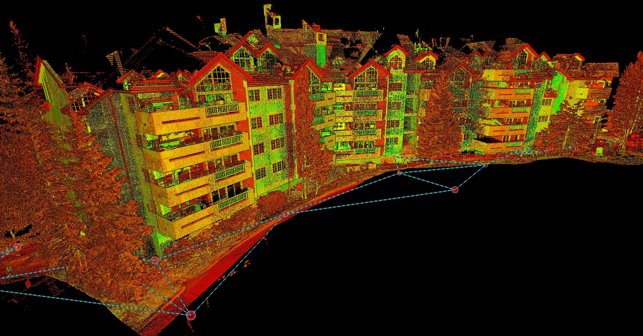
Why LiDAR Scanning for Scaffolding Design Matters
LiDAR scanning for scaffolding design is not the first use case that comes to mind when people think about reality capture. Many construction professionals associate laser scanning with renovation drawings, BIM models, and existing condition documentation.
A recent project at St. James Place in Beaver Creek demonstrated another valuable application.
Hyder Construction was preparing for a large exterior renovation that included replacing windows and railings throughout the property. Before crews could begin that work, engineers needed to develop a scaffolding plan that accounted for the building’s surroundings, site access, terrain, and safety requirements.
That challenge had little to do with the windows.
It had everything to do with understanding the site.
A Mountain Property With Unique Conditions
St. James Place sits within a mature mountain environment in Beaver Creek, Colorado. The property includes significant grade changes, retaining walls, pedestrian walkways, mature trees, and landscaped areas that surround the building perimeter.
Those conditions create challenges for temporary works planning.
Scaffolding systems require support locations, access routes, material staging areas, and safe working clearances. Engineers cannot develop an effective design without understanding the environment where the system will operate.
Hyder Construction recognized that reality early in the planning process.
Instead of waiting until scaffolding crews arrived on site, they wanted accurate information before engineering moved forward.
That decision brought Precision 3D Scanning onto the project.
Capturing Existing Conditions Before Engineering Began
Our team performed a comprehensive exterior LiDAR scan of the building and surrounding site.
The objective was straightforward.
Capture the conditions that could influence scaffolding design.
The scan documented the building exterior, retaining walls, grade transitions, mature tree locations, landscape features, pedestrian pathways, and surrounding terrain.
The resulting point cloud provided engineers with a complete representation of the environment around the building.
Instead of relying on assumptions, aerial imagery, or isolated field measurements, the team could evaluate actual site conditions from the office.
That level of visibility improves decision-making before mobilization begins.
Why Existing Conditions Affect Scaffolding Design
Temporary works often receive less attention than permanent construction.
However, scaffolding systems carry significant planning, coordination, and safety requirements.
Every project site presents different constraints.
A mature tree may limit equipment placement.
A retaining wall may reduce available space.
An elevation change may affect support locations.
A pedestrian route may require additional protection.
Engineers can solve those challenges when they identify them early.
The difficulty begins when teams discover those conditions after decisions have already been made.
At that point, redesign, rework, and schedule impacts become much more likely.
Safety Starts During Planning
Safety was one of the primary drivers behind this effort.
Construction teams spend considerable time planning how work will occur safely. That planning becomes more effective when teams understand the environment before equipment arrives on site.
The LiDAR scan gave the project team an accurate understanding of site conditions before scaffolding engineering moved forward.
That information helped engineers evaluate access, clearances, support conditions, and surrounding obstacles during the planning phase.
The goal was not simply to build scaffolding.
The goal was to develop a scaffolding plan that reflected reality.
That distinction matters.
Construction teams make better decisions when they work from measured conditions instead of assumptions.
The Cost of Discovering Conditions Too Late
Schedule problems rarely originate from a single major mistake.
Small discoveries create larger impacts when teams uncover them late in the process.
An access route changes.
A support location moves.
Equipment no longer fits the intended location.
Additional engineering becomes necessary.
Field crews stop while teams determine a solution.
Those events consume time and money.
The earlier a team identifies site constraints, the easier those constraints become to manage.
LiDAR scanning for scaffolding design helps shift those discoveries into planning, where solutions cost less and cause fewer disruptions.
Why Hyder Construction Chose a Proactive Approach
One aspect of this project stands out.
Hyder Construction chose to verify conditions before questions emerged.
That proactive approach reflects strong preconstruction planning.
Rather than reacting to obstacles after mobilization, the team sought clarity before engineering and installation began.
That decision created value for everyone involved.
The engineers gained reliable information.
The project team reduced uncertainty.
The site moved closer to construction with fewer unknowns.
Reality First, Then Planning
The St. James Place project demonstrates an important principle.
LiDAR scanning does more than support BIM models and renovation drawings.
Accurate reality capture improves planning.
It improves safety.
It improves coordination.
It improves decision-making.
In this case, LiDAR scanning for scaffolding design helped the team understand the environment surrounding the building before construction began.
That understanding allowed engineers to develop a plan based on measured reality instead of assumptions.
Construction works better when truth is clear, shared, and measurable.
That belief guides every project we undertake at Precision 3D Scanning.
When teams understand existing conditions early, they make better decisions before cost, delay, or risk enters the project.
Similar Posts:
https://precision3dscanning.com/lidar-survey-control/
3D Laser Scanning Existing Conditions in Denver