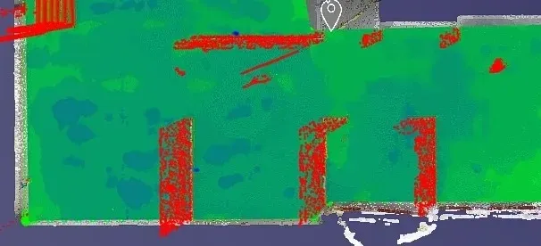
Concrete Elevation Heat Maps in action.

Title: Unveiling the Beauty of Concrete Elevation Heat Maps: Precision 3D LiDAR Scanning
In the dynamic world of architecture and construction, innovation meets precision through 3D LiDAR scanning. This groundbreaking technology unlocks a realm of possibilities, transforming mundane structures into visually breathtaking Concrete Elevation Heat Maps.
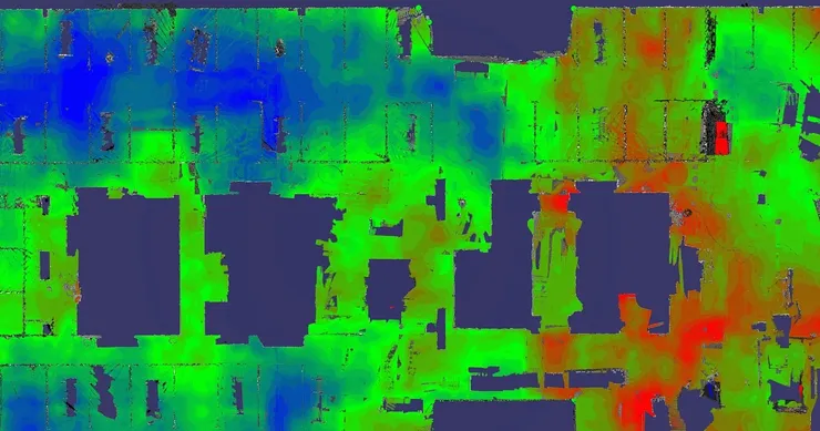
Concrete elevation deviations become evident when viewed through the lens of precision 3D LiDAR scanning. Every contour, every gradient, meticulously captured and transformed into stunning elevation heat maps.
These maps offer architects and designers an unprecedented level of insight into the very essence of concrete structures. No longer confined to two-dimensional blueprints, they can now explore every nuance and intricacy in three-dimensional glory.
Creation of Concrete Elevation Heat Maps:
The process begins with the deployment of state-of-the-art LiDAR scanners, meticulously mapping the surface of concrete structures with unparalleled accuracy. These scanners emit laser pulses, bouncing off surfaces and capturing data points with astonishing precision.
As the scanning progresses, a digital representation of the concrete structure begins to emerge. Each data point meticulously cataloged, forming the foundation for the creation of the breathtaking elevation heat maps.
Through the magic of advanced algorithms, these data points are transformed into vibrant visual representations. Every rise, every fall, every curve of the concrete structure brought to life in vivid detail.
The result is nothing short of mesmerizing. A symphony of colors cascading across the canvas, revealing the intricate topography of concrete in all its glory. From towering skyscrapers to humble sidewalks, each structure takes on a new dimension of beauty.
But the true beauty of these elevation heat maps lies not only in their visual appeal but also in their practical applications. Architects and engineers can now analyze concrete structures with unprecedented precision, identifying potential weaknesses or areas for improvement with ease.
Structural integrity, once a matter of conjecture, can now be assessed with scientific precision. Whether it’s evaluating load-bearing capacity or detecting subtle signs of deterioration, 3D LiDAR scanning revolutionizes the way we perceive and interact with concrete structures.
Moreover, these elevation heat maps serve as invaluable tools in the realm of urban planning and development. City planners can now visualize the impact of proposed changes to the urban landscape with unparalleled accuracy, ensuring a harmonious balance between form and function.
In conclusion, precision 3D LiDAR scanning breathes new life into the world of concrete architecture. By transforming mundane structures into breathtaking works of art, elevation heat maps offer a glimpse into the future of design and construction. With every scan, we unveil the hidden beauty of concrete, one data point at a time.