Client: Mark Young Construction
Location: Colorado Springs, Colorado
Mark Young Construction embarked on a significant renovation of the Colorado Springs Fire Department Station #25, only to face a critical challenge: the station’s garage had long struggled with persistent drainage issues. This problem disrupted daily operations and posed a serious obstacle to the project’s success. Before proceeding, it was essential to diagnose the root cause and develop a precise, actionable solution.
Leveraging LiDAR Scanning
To achieve this, Mark Young Construction enlisted the expertise of Precision 3D Scanning, a company specializing in advanced LiDAR scanning technology, to provide the detailed data required to tackle the problem head-on.
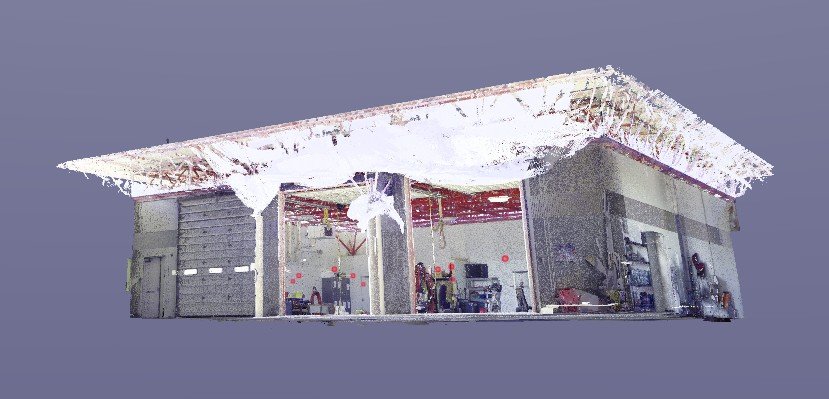
(A wide-angle view of the fire station’s garage, providing a clear visual context for the drainage issues faced by the team. The image highlights the scope of the challenge and the complexity of the renovation project.)
Identifying the Challenge
The garage’s drainage problems represented a significant risk. Without a clear understanding of the scope, the potential for miscalculations could lead to costly delays. To prevent this, the LiDAR scanning process was meticulously planned and executed. By creating a digital replica of the garage, including its concrete slab, the team was able to analyze the issue in extraordinary detail.
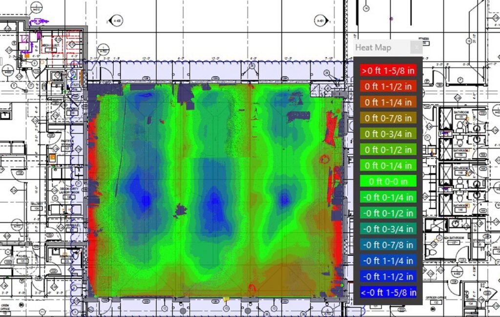
(A detailed heat map of the garage floor, vividly showcasing elevation differences in 1/4-inch increments. The map clearly highlights problematic areas, helping the team pinpoint corrections needed for proper drainage.)
One of the most critical deliverables was a color-coded topographical map of the concrete slab, with elevation differences displayed in precise 1/4-inch increments. This map vividly highlighted the high and low points contributing to the drainage issues, allowing the construction team to pinpoint exactly where corrections were required. Additionally, the scan quantified the volume of concrete needing adjustment, giving the design and construction teams the confidence to move forward with precise modification plans.
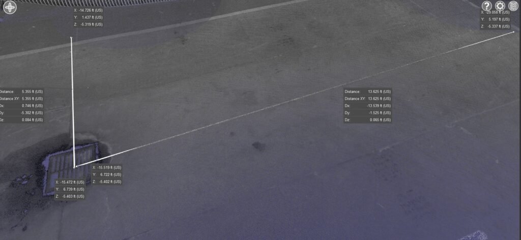
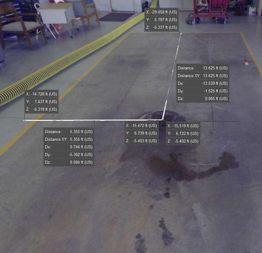
(A close-up view of key measurements captured within the point cloud. This visualization illustrates the precision and level of detail achieved through LiDAR scanning, demonstrating its value in guiding the renovation process.)
Visual Documentation and Utility
The value of LiDAR extended far beyond these measurements. The scan produced a complete point cloud of the garage. A detailed 3D model that became the cornerstone of ongoing design and construction efforts. This model enabled the team to map out necessary adjustments with accuracy, ensuring that proposed designs perfectly aligned with the existing structure. High-resolution, 360-degree images captured at each scan location provided an immersive visual reference, allowing the team to identify problem areas and plan solutions without requiring repeated site visits.
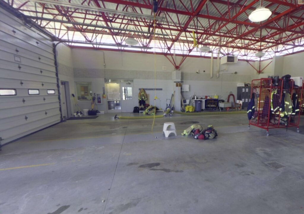
(A high-resolution, 360-degree image offering an immersive perspective of the garage’s interior. This photo showcases the conditions before renovation and serves as a valuable reference point for the design and construction teams.)
These resources empowered the renovation team to make informed, confident decisions, ultimately ensuring the project’s success.
With this wealth of data, the construction team advanced with assurance. The color-coded topographical map transformed the process of diagnosing drainage issues, saving invaluable time and effort. Precise measurements eliminated material waste, ensuring that only the necessary amount of concrete was used. Furthermore, the detailed point cloud and high-resolution images enhanced the overall efficiency of the renovation process. This enabled fostering seamless collaboration among team members and improving coordination across the board.

The visuals captured during this project added an additional layer of clarity and utility. The color-coded map highlighted high and low points of the concrete slab, providing a clear guide for corrections. The comprehensive 3D point cloud offered a complete view of the garage’s dimensions, aiding in precise planning. High-resolution, 360-degree photographs presented a fully immersive perspective of the garage’s pre-renovation condition. This helped by enabling stakeholders to visualize the challenges and proposed solutions. Images showcasing the LiDAR equipment in action further demonstrated the advanced technology that drove the project’s success.
Transformative Impact
The LiDAR scanning process at Colorado Springs Fire Station #25 played a transformative role in addressing the garage’s drainage issues. By delivering precise data and highly detailed visuals, the team established a solid foundation for a targeted and cost-effective renovation. This approach not only resolved the immediate challenges but also showcased how advanced technology can revolutionize complex renovation projects. The case study underscores the critical importance of precision and efficiency in modern construction. Also, highlighting the immense value of integrating innovative tools to achieve exceptional results.
See more Case Studies here: https://precision3dscanning.com/category/case-studies/
Find out more about Precision 3D Scanning here: https://precision3dscanning.com/